BRIDGE OVER PHAYA THAI ROAD
All projects were submitted on October 5, 2010 and listed in alphabetical order of student nickname.
The project brief states project and submission requirements
AEI
Image below shows the plan view of the bridge with removed rooftop. If look closely, one can notice the red dots on the bridge. Those marks represent louvers that direct and frame viewers to look within the campus area. Based on research analysis, not all existing four stairs are used equally throughout the day. Hence, two out of four landings is selected and applied on the design.Originally, the main idea is to design a bridge that frames and directs viewer to look within Chulalongkorn University campus. Since one of my intention is to raise users' awareness about the campus, one of the bridge wall is turning away from the shopping area, allowing users to be in a education area only. However it has become more visible towards the end that my concept is no longer merely about directing or framing views. Instead, the concept starts to integrate the idea of creating an isolated and peaceful environment on the bridge.
Diagram below illustrates viewing directions from the bridge. The elongated pale pink triangle represents the center zone which is pointing towards the rest of Chulalongkorn University campus. The opposite side is where all the shopping area is located. From entrance, the bridge make users turn their backs and looking towards the rest of university area. Part of the design is to have this uniform bridge, turning its back towards the entertainment zone and make users focus within educational environment. Hence, the diagram intends to convey the message by using multiple dotted lines pointing towards different parts of the campus.
North elevation shows the bridge with its back towards the shopping area. Looking from a distance, it appears as though the wall on the bridge is almost solid. Here, louvers is angled toward buildings along the main road, forbidding users to even have a slight glance at the shopping centres.
Unlike north elevation, louvers along south elevation has more movement. It direct and frame viewers to look at various area of the campus. Hence, this side of the wall appears to be less tightly aligned.
East elevation shows part of the bridge entering campus area, in front of faculty of Architecture. The elongated zone moves through the tree opening directing user to look towards the main auditorium and statue of Rama V. It also allow users to have peaceful sensation while occupying the space.
West elevation displays the view from parking area that is opposite faculty of Architecture. Like the prior extended part (see image above, east elevation) this extension also moves through trees opening.
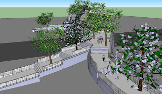
Rendered bridge
Series of physical model images:
Looking from Campus area, in front of Faculty of Architecture
Perspective view, looking at the frontal part of the bridge.

Focusing on one of the stairs and how the bridge can be occupied
One of the three isolated zones. This one extends in to the campus, looking out through trees opening.
BO :
THE TUbE
green bridge project-1
water system build in the construction |
elevation
final model |
sketchup drawings
cut section1 |
cut section2 |
Bom ::::::::::::::::::::
The original bridge model
First study model, focusing on the accessible greenspace
Second model, thinking more of the space.
Different materials are shown by using different kind of chan-oy and cardboard
Third study model, playing with space, so it won't look symmetrical
There are seatings for users with the major circulation route for people to cross
A section of 1:50 model
Fourth study model
Final model, providing users various kind of seating for different needs and satisfactions
Different levels of trees for users to obtain different perceptions along the footbridge
Different levels seating for users to experience different perceptions
Provided shade all along the footbridge to protect from both rain and sun ray
What it looks like placing on a site model
Axon projection informing materials, layers and properties
CAKE

This is a photograph of my overall bridge design where my bridge is categorized into three types of walking speed of slow ("chillers"), medium ("strollers"), and fast ("rushers"). As seen on the model, the "chiller"'s route is the green space, the "stroller"'s route is the ramps, and the "rusher"'s route is the tunnel.

This is the top view of my model where only the green space and the ramp is visible. The tunnel is not seen since the green space uses the roof of the tunnel as its ground while the ramps are connected to the side of the tunnel.

This is the close up of the "stroller"'s route where you can see the ramps changing direction and rising up (according to the ramp ratio of 1:12) towards the green space.

This is a close up of the green space where there are limited number of seats. This image presents only one seat while the actual space would contain 4 seats in total to maintain privacy for this chilling area. The materials seen here is wood and the pathway that leads you to the seats are curved to represent the longer walk and the more time duration you can spare when you see this bridge as a destination.

This is an image of the plan of my bridge where you can see the two routes with another route under it that's not visible. The two sides of the stairs are different to refer back to the site analysis that our faculty side will have one stair that leads into the campus to show that most "rushers" are Chula students. Conversely, the opposite side of the faculty would have 2 stairs branching out to the sidewalks to show that most users come from either MBK, Samyan and etc., not from the parking lot.

This image shows how the stairs on the side of our faculty connects right into the campus to the inside of Baan Rai Coffee where the shade is located.

This image shows the "rusher"'s route where it is a tunnel that is all closed except for the entrance and exit. The tunnel has four lanes for people to walk orderly. The light at the end of the tunnel is the point of reference that points out the destination.

This image shows the "stroller"'s route where the ramps rises up and changes direction according to the ramp ratio. There are two options for this route where the first one is you can choose to cross to the other side with a longer walk which is distinguished from the "rushers" or you can choose to see the bridge as the destination and head up to the green space where the "chillers" are.
PLOY
Concept : Destruction of uniformity
When looking at the whole picture of the community, the existing bridge is seen as being uniformed. All bridges which connect Chula campus together along Phayathai Road were constructed the same way, however, they are unique in their own ways due to the differences in the environmental conditions. To emphasize the uniqueness, the new design is to further destruct the sense of uniformity by contrasting the original form and shape of the existing design.
SAMY
< Bridge as a apart of Chula Campus>
Through this studio project, I wanted this pedestrian bridge to act as a smooth connection between both sides of Campus as being a part of Chula campus, not a complete stranger like current pedestrian bridge.
To give the users sequential experience and the feeling of continuity, I thought that functional and aesthetical correlation with the site-Phayathai road and Chula campus - is needed. So I decided to deal with the activities happening on the site ,that are poorly served by the site, to have functional similarity with better solution. Also, I decided to use similiar/same materials to provide sequential feelings.
Left side is where there is parking lot. Faculty of Architecture building is on the right side. I decided to remove the existing fence and make stairs starting inside of both sides of campus. Talking about smooth connection, I thought that entrances and the exits are very cruial. Starting from the architecture building side , the stairs are connected from the patio on the left end of the building which is purposed invite pedestrians by providing a very open entrance to the bridge- no clear boundary. Since there is a cafe, they can sit around and rest which would encourage them to be more interacted with the entrance. Also, for the parking lot side, I decided to put a skywalk along the middle rows of cars where they receive direct sunlights unlike the rows at the edges where trees are making shades. The stairs are insterted into spaces provided for plants at the end of a sidewalk so that they can easily access from the sidewalk. Also the stairs are rising from 2 sides of space for plants which creates another entrance/exit for the pathwalk in between cars. so people who parked their cars and approaching towards the Jamjuri 5 building would walk under the shades of bridge. Therefore, the both ends of the footbridge are suggesting functional continuity.
Top view
Side view

Front view of 1st model
Top view of 2nd study model.
Side view of 2nd model
Perspective view < approaching from Faculty of Architecture >
Perspective view < approaching from Jamjuri 5>
Perspective view< approaching from parking lot towards the performance space >
Bridge looking from top< Yellow: Bridge, Red: stairs touching ground >
Final model <Side view>
Performance space <Side view>
Parking lot side
Faculty side
Front view < from faculty of architecture>
walking into the performance space
looking down from the green space
walking down to the parking lot side
Top view1
Top view2
YIPTA


No comments:
Post a Comment